

When it comes to compliance, you and your commercial drivers can breathe easy. Azuga ELD meets or exceeds FMCSA 395.15 regulations for HOS and DVIRs—and it meets all requirements for the ELD (Electronic Logging Device) mandate. An addition to Azuga Fleet, ELD is simple to use and brings ease and accuracy to log keeping.
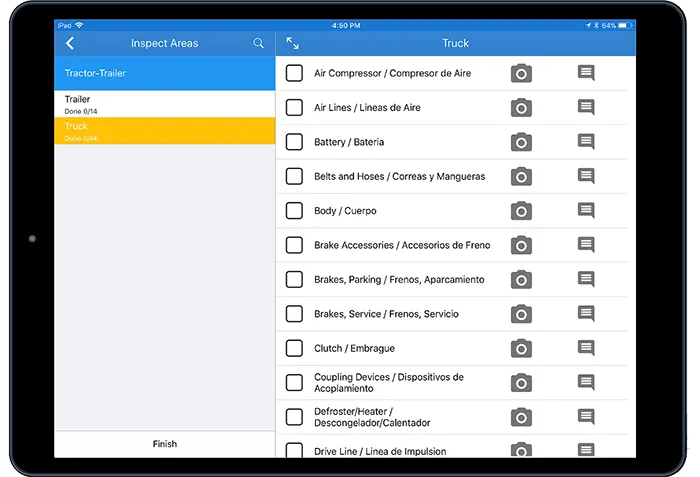
Easy to use, Azuga ELD simplifies HOS (Hours of Service) and DVIR (Driver Vehicle Inspection Report) requirements—and ensures you're always up-to-date with the latest rules and regulations.
From in-depth data to proactive alerts, Azuga ELD provides the insight you need to reduce violations and avoid fines.
Azuga ELD streamlines compliance operations, automating time-intensive tasks so your staff can do their jobs more efficiently.


"We are a family run and co-owned business. I trust my technicians, but Azuga helps me verify the information and encourage better driving habits."
Matt Berrena
President & Co-owner
Read Story"Drivers have become accustomed to Azuga, are mindful of their driving behavior and the scores have improved dramatically."
Peter Veilleux
Operations Manager, Air Engineers
Read Story"Azuga GPS device is next-gen GPS. It’s easy to install, portable between vehicles and provides valuable business insight into asset tracking, fuel wasting behavior, vehicle maintenance schedules and driver performance. We recently switched to Azuga from a hard-install GPS provider and are delighted at the results."
Remy Cano
President
Read Story"Azuga has been everything and more than expected, creating a highly engaged workforce, empowering each employee to modify his/her driving behavior in real-time."
Chris McKeeman
VP, EHS
Read StoryIn an ELD Mandate compliant vehicle, an eLog device is installed to track HOS data. The device is a GPS tracker with wireless communication capabilities. This device connects with the vehicle’s engine to automatically transmit data whenever the vehicle is in operation. It also records data entered by the driver. It must record the following information to be compliant:
Drivers are responsible for recording their status through their driving log software. The possible designations are:
Whenever a driver changes their status, the device also automatically records the driver’s location (city and state).
The ELD rule applies to motor carriers and drivers who are currently required to keep records of duty service (RODS) under the hours-of-service (HOS) regulations. If a commercial vehicle requires a USDOT number, it also needs to record ELD logs. This includes commercial buses and trucks used to transport products or people for interstate business, plus all vehicles that have a gross vehicle weight of >10,000 lbs.
There are a few ways some fleet drivers may be exempted from the ELD mandate. These include:
Yes. The ELD Rule accommodates the use of smartphone (Android/iPhone) and other wireless devices as ELDs—as long as they meet the necessary technical specifications. If you’re not sure if a specific ELD qualifies, check the Registered ELDs list from FMCSA.
Feel free to visit the official FMCSA resources on ELDs and the ELD Rule. We also have an ELD guide available here. Feel free also to check out our blog articles on the subject.
An ELD (Electronic Logging Device) is technology that automatically records a driver’s driving time and other aspects of the hours-of-service (HOS) records. The ELD monitors a vehicle’s engine to capture data on whether the engine is running, whether the vehicle is moving, miles driven, and duration of engine operation (engine hours). With an ELD, law enforcement can review a drivers hours of service by viewing the ELD’s display screen, a printout from the ELD, or retrieving data electronically from the ELD device.
The first deadline for the FMCSA’s ELD mandate was December 18th, 2017. All drivers and carriers subject to the ELD mandate had to have either an ELD or an AOBRD installed in their vehicle. After December 16th, 2019, AOBRDs could no longer be used to be compliant with the ELD mandate. If your fleet is still using AOBRDs, you are no longer compliant with the ELD mandate.
PRODUCTS
INDUSTRIES
RESOURCES

GPS Fleet Management Software that is simple to use, affordable, customizable and easy to install.
© 2024 Azuga, a Bridgestone Company. All rights reserved.


